Lemuria was an ancient civilization which existed prior to and during the time of Atlantis. Physically, it is believed
that Lemuria existed largely in the Southern Pacific, between North America and Asia/Australia. Lemuria is also sometimes
referred to as Mu, or the Motherland (of Mu). At its peak of civilization, the Lemurian people were both highly evolved and
very spiritual. While concrete physical evidence of this ancient continent may be difficult to find, many people "know" that
they have a strong connection to Lemuria.
Lemuria (pronounced /lɨˈmjʊəriə/)[1] is the
name of a hypothetical "lost land" variously located in the Indian and Pacific Oceans. The concept's 19th century origins
lie in attempts to account for discontinuities in biogeography; however, the concept of Lemuria has been rendered obsolete
by modern theories of plate tectonics. Although sunken continents do exist — like Zealandia in the Pacific and the Kerguelen
Plateau in the Indian Ocean — there is no known geological formation under the Indian or Pacific Oceans that corresponds
to the hypothetical Lemuria.
Though Lemuria is no longer considered a valid scientific hypothesis, it has been adopted
by writers involved in the occult, as well as some Tamil writers of India. Accounts of Lemuria differ, but all share a common
belief that a continent existed in ancient times and sank beneath the ocean as a result of a geological, often cataclysmic,
change. There is no scientific evidence to support these claims.
In 1864 the zoologist and biogeographer Philip Sclater
wrote an article on "The Mammals of Madagascar" in The Quarterly Journal of Science. Using a classification he referred to
as lemurs but which included related primate groups,[2] and puzzled by the presence of their fossils in both Madagascar and
India but not in Africa or the Middle East, Sclater proposed that Madagascar and India had once been part of a larger continent.
He wrote:
The anomalies of the Mammal fauna of Madagascar can best be explained by supposing that... a large continent
occupied parts of the Atlantic and Indian Oceans... that this continent was broken up into islands, of which some have become
amalgamated with... Africa, some... with what is now Asia; and that in Madagascar and the Mascarene Islands we have existing
relics of this great continent, for which... I should propose the name Lemuria![2]
Sclater's theory was hardly unusual
for his time. Étienne Geoffroy Saint-Hilaire, also looking at the relationship between animals in India and Madagascar, had
suggested a southern continent about two decades before Sclater, but did not give it a name.[3] The acceptance of Darwinism
led scientists to seek to trace the diffusion of species from their points of evolutionary origin. Prior to the acceptance
of continental drift, biologists frequently postulated submerged land masses in order to account for populations of land-based
species now separated by barriers of water. Similarly, geologists tried to account for striking resemblances of rock formations
on different continents. The first systematic attempt was made by Melchior Neumayr in his book Erdgeschichte in 1887. Many
hypothetical submerged land bridges and continents were proposed during the 19th century, in order to account for the present
distribution of species.
After gaining some acceptance within the scientific community, the concept of Lemuria began
to appear in the works of other scholars. Ernst Haeckel, a German Darwinian taxonomist, proposed Lemuria as an explanation
for the absence of "missing link" fossil records. According to another source, Haeckel put forward this thesis prior to Sclater
(but without using the name 'Lemuria').[4] Locating the origins of the human species on this lost continent, he claimed the
fossil record could not be found because it had sunk beneath the sea.
Other scientists hypothesized that Lemuria had
extended across parts of the Pacific oceans, seeking to explain distributions of species across Asia and the Americas.
[edit]
Superseded The Lemuria theory disappeared completely from conventional scientific consideration after the theories of plate
tectonics and continental drift were accepted by the larger scientific community. According to the theory of plate tectonics
(now the only accepted paradigm in geology), Madagascar and India were indeed once part of the same landmass (thus accounting
for geological resemblances), but plate movement caused India to break away millions of years ago, and move to its present
location. The original landmass broke apart - it did not sink beneath sea level.
In 1999, drilling by the JOIDES Resolution
research vessel in the Indian Ocean discovered evidence [5] that a large island, the Kerguelen Plateau, was submerged about
20 million years ago by rising sea levels. Samples showed pollen and fragments of wood in a 90 million-year-old sediment.
Although this discovery might encourage scholars to expect similarities in dinosaur fossil evidence, and may contribute to
understanding the breakup of the Indian and Australian land masses, it does not support the concept of Lemuria as a land bridge
for mammals.
If this continent were to exist, Australia would have to be sideways while attached to half of Antarctica
and Madagascar. Sir Lanka would also be attached to Australia while India would need to have drifted more from its current
position it is in today. For Australia to be in its current position it is in today, the polar shift theory of a northern
boundary in the east would have to be incorporated. There would be a river in between the two continents and it would extend
eastward to a larger, now submerged portion of the continent known as Mu.
[edit] Blavatsky, Elliot, and Bramwell
Map
of Lemuria superimposed over the modern continents from Scott-Elliott's The Story of Atlantis and Lost Lemuria.Lemuria entered
the lexicon of the Occult through the works of Helena Blavatsky, who claimed in the 1880s to have been shown an ancient, pre-Atlantean
Book of Dzyan by the Mahatmas. According to L. Sprague de Camp, Blavatsky's concept of Lemuria was influenced by other contemporaneous
writers on the theme of Lost Continents, notably Ignatius L. Donnelly, American cult leader Thomas Lake Harris and the French
writer Louis Jacolliot.[6]
Within Blavatsky's complex cosmology, which includes seven "Root Races", Lemuria was occupied
by the "Third Root Race", described as about 7 feet (2.1 m) tall, sexually hermaphroditic, egg-laying, mentally undeveloped
and spiritually more pure than the following "Root Races". Before the coming of the Lemurians, the second "Root Race" is said
to have dwelled in Hyperborea. After the subsequent creation of mammals, Mme Blavatsky revealed to her readers, some Lemurians
turned to bestiality. The gods, aghast at the behavior of these "mindless" men, sank Lemuria into the ocean and created a
"Fourth Root Race"—endowed with intellect—on Atlantis.[citation needed]
One of the most elaborate accounts
of lost continents was given by the later theosophical author William Scott-Elliot. The English theosophist received his knowledge
from Charles Webster Leadbeater, who communicated with the Theosophical Masters by "astral clairvoyance." In 1896 he published
The Story of Atlantis, followed in 1904 by The Lost Lemuria, in which he included a map of the continent of Lemuria as stretching
from the east coast of Africa across the Indian and the Pacific Oceans.[7]
James Bramwell described Lemuria in his
book, Lost Atlantis, as “a continent that occupied a large part of what is now the South Pacific Ocean.”[8] Bramwell
described the people of Lemuria in detail and attributed them with being one of the “root-races of humanity.”
According to Bramwell, Lemurians are the ancestors of the Atlanteans, who survived the period “of the general racial
decadence which affected the Lemurians in the last stages of their evolution.” From “a select division of”
the Atlanteans - after their promotion to decadence - Bramwell claims the Aryan race arose. “Lemurians, Atlanteans,
and Aryans are root-races of humanity,” according to Bramwell.[9]
[edit] Lemuria and Mount Shasta In 1894,
Frederick Spencer Oliver published A Dweller on Two Planets, which claimed that survivors from a sunken continent called Lemuria
were living in or on Mount Shasta in northern California. Oliver claimed the Lemurians lived in a complex of tunnels beneath
the mountain and occasionally were seen walking the surface dressed in white robes.
This belief has been repeated by
such individuals as the cultist Guy Warren Ballard in the 1930s who formed the I AM Foundation. It is also repeated by followers
of the Ascended Masters and the Great White Brotherhood. This list includes such organizations as Bridge to Freedom, The Summit
Lighthouse, Church Universal and Triumphant, and The Hearts Center. Nowadays this thesis is also described by Kryon.[citation
needed]
[edit] Kumari Kandam and Lemuria
"Lemuria" in Tamil nationalist mysticist literature, connecting Madagascar,
South India and Australia (covering most of the Indian Ocean).Kumari Kandam is a legendary sunken kingdom sometimes compared
with Lemuria (cf. works of G. Devaneyan, Tamil: ஞானமுத்தன் தேவநேயன்).
In Tamil tradition, Kumari Kandam is referred to as the Land of Purity, a sophisticated kingdom of higher learning, located
south of Kanyakumari or Cape Comorin. During a violent geologic catastrophe the entire island was submerged under the water.
The survivors migrated to the present Indian subcontinent and supposedly sparked the Indus Valley Civilization. This mass
of land is often compared to the island of Lemuria.[10]
According to these modernist interpretations of motifs in classical
Tamil literature — the epics Cilappatikaram and Manimekalai that describe the submerged city of Puhar[11]— the
Dravidians originally came from land south of the present day coast of South India that became submerged by successive floods.
There are various claims from Tamil authors that there was a large land mass connecting Madagascar and Australia from the
Southwest and Southeast respectively to the present-day Kanyakumari District coast.
Another piece of literature in
Ayyavazhi mythology, specifically Akilathirattu Ammanai speaks of a sunken land about 152 miles south of present day Kanyakumari.
It goes on to describe the civilization with exactly 16008 streets
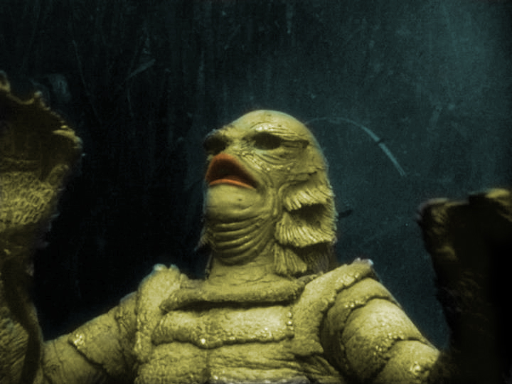
According to producerWilliam Alland, the idea behind the film was originally thought up by an unnamedBraziliandirector whom he met at the home ofOrson Welles. The unnamed man spoke of a friend of his who disappeared in the Amazon in an attempt at filming a documentary
on a rumored population of fish people.[1] There were various designs for the creature. William Alland envisioned the creature as a "sad, beautiful monster" and
thesculptureof it was much like that of an aquatic development of a human. Alland said, "It would still frighten
you, butbecause how human it was, not the other way around". Originally, the creature's design was meant to incorporate a sleek, feminineeel-like figure, which did not have as many bumps and gills as the final version. The designer of the approved
Gill-man wasDisneyanimator Millicent Patrick, though her role was deliberately downplayed by makeup artistBud Westmore, who for half a century would receive sole credit for the creature's conception.[1] The Gill-man suit was made fromairtightmolded sponge rubber and cost $15,000.[2] The underwater sequences were filmed atWakulla Springsin North Florida (today a state park), as were many of the rear projection images. Part of the film
was shot inJacksonville,Floridaon the south side of the river near the foot of the oldAcosta Bridge. The underwater Gill-man suit was painted yellow for greater visibility in the dark waters.[1] Air was fed into the suit with a rubber hose.
The Gill-man is fullyamphibious, capable of breathing both in and out of the water. As shown in the first film, it is vulnerable torotenone. It also possessessuperhumanstrength, which is flamboyantly displayed in the second and third films. It also possesses large, webbed
hands with sharp claws on the tip of each finger. The Gill-man's scaly skin is extremely tough, which combined with a fast
acting healing factor, allows it to survive wounds which would be fatal to humans, such as gunshots and fullimmolation. As shown in the third film, the creature has a dormant set oflungs, should itsgillsbe irreparably damaged. The Gill-man is slightlyphotophobic, due to its murky water habitat.[5] 35% of the Gill-man's blood is composed ofwhite corpuscleslacking a nucleus.
Chichen Itza
LOCATION
Chichen Itza, Mexico (Latitude 20°40'N | Longitude 88°32'W) Chichen Itza is the most visited archaeological
site in the peninsula of Yucatan, due to its extraordinary architecture beauty and its geographical location. It is located
120 km from Merida (about midway between the towns of Cancun and Merida) in the State of Yucatan, Mexico.
Location of Chichen Itza in Yucatan Peninsula, Mexico
Layout of the ruins of Chichen Itza
Chichen Itza, Mayan culture, late classic, 11-13th A.D.
The site was developed between the 6th and 14th centuries. The early inhabitants (A.D. 600-900) were the Itzá, a Maya
group. Chichen Itza seems to have been abandoned during the 10th century but later resettled around A.D. 1000. The second
group of settlers may have been the original Itzá, Toltecs from Tula (near Mexico City), or a fusion of both groups.
Archaeologists have recognized both Maya and Toltec influences in the architecture: most believe that the Toltecs influenced
the Itza, but some argue that the influence was in the other direction.
It was founded in the year 514 of our era by the priest LAKIN CHAN who was also called Itzamna. This is why their people
were called since the foundation, chanes or itzaes.
The name Chichen Itza, is derived from the Mayan language: "Chi" - mouth, "Chen" - well and "Itza" - the tribe that inhabited
the area. When the Spaniards arrived to Chichen - Itza, it had been abandoned as a consequence of the civil war fought with
Mayapan. In between 1196 and 1441 the final collapse of this culture took place in the north of the peninsula.
The conquerors found the buildings of Chichen Itza, partially in ruins and their names and real use were unknown; this
is why the present names are suppositions.
About 60% of El Castillo pyramid has been restored almost fully from the decaying condition in which it was re-discovered
by John L. Stephens in 1841 although the eastern and southern faces are still partially eroded by the forces of time and erosion.
There are no plans to restore these two faces of the pyramid as those that restored the other portions wish for future generations
to see the condition in which it was originally discovered.
Drawings of the Nunnery
Artist's rendering of central Chichen Itza around the year AD 1,000. View is from the north with the Castillo
Pyramid in the center, Temple of the Warriors to the east, and a sacbe to the Sacred Cenote in the foreground. Source:http://maya.csuhayward.edu/archaeoplanet/97GprGra/97Photos/Fig06.htm
Chichen Itza is the most impressive and intact ruins of Mayan civilization that the modern world has. This now popular
tourist attraction is located on the Yucatan Peninsula of Mexico and has fast become the best restored record of the spiritual,
domestic, and agricultural lives of these people. Mayan ruins in central America, such as Chichen Itza, are remnants of cities
that were abandoned long before Columbus reached the area; yet this culture has influenced many areas of architecture, art,
and astronomy, that live on even in our modern world.
The Mayan people are most famous for their brilliant and advanced astronomical knowledge and their resiliency. Stone remnants
of their civilization are currently being preserved at various sites in Mexico; in Tilkal, Guatemala; in Altun Ha, Belize;
and in Copan, Honduras. Mayan civilization spread from their origin on the Yucatan Peninsula to the rain forests of Mexico
eastward and the other surrounding countries. Today, mostly on the Yucatan Peninsula and in the state of Chiapas, Mayan culture
is still thriving with four to six million people, over 30 languages, and many ethnic backgrounds represented. Modern Mayans
still continue many of the traditions of their ancient culture, such as speaking their ancient dialects instead of Spanish,
growing their traditional crops (corn, beans, chile, tomatoes, and squash) with the same techniques, and using herbal medicinal
treatments instead of modern medicine. Many spiritual aspects of Mayan life, the purpose for their ancient cities, is still
exercised with many offerings and pilgrimages to modern churches, sometimes fusing Catholicism with Mayan beliefs from antiquity.
Around 550 AD, Mayans settled Chichen (translated "the mouth of the well") around two wells; one sacred and one "profane,"
used for everyday use. These underground wells and subsequent waterways, known as "cenotes", were the lifeblood of the community.
Chichen Itza was primarily a rain forest area settled on flat, porous limestone that rain seeped through to became trapped
in the insolvent bedrock below. These cenotes were, therefore, the oasis of the society, full of rain and run off water for
their living needs. Chichen Itza, like most Mayan centers, was primarily a spiritual, ceremonial site instead of a commercial
area. The loose arrangement of decentralized farming communities came together for offerings, sacrifices, and ceremonies in
the town. Some trade, education, and recreation were also performed there. Exhumed from the sacred well were many ceremonial
objects, skulls, and entire skeletons.
Evidence suggests that Chichen Itza was abandoned by the Mayans in the tenth century. This is concurrent with evidence
of all Mayan cities being abandoned around this period. The abandonment has not yet been fully explained. The Mayans returned
to and resettled their cities around 1000 AD. Chichen Itza's architecture is seen to have two distinctive styles; traditional Mayan architecture, and more recent Toltec architecture.
The Toltecs were another more warlike tribe who invaded Chichen Itza around the year 800 AD. The Toltecs were much more fierce
than the Mayans and human sacrifice was a large part of their rituals. It is quite easy to decipher which structures in Chichen
Itza were built before and after 800 AD.
Easter Island
One of the world's most famous yet least visited archaeological sites, Easter Island is a small, hilly,
now treeless island of volcanic origin. Located in the Pacific Ocean at 27 degrees south of the equator and some 2200 miles
(3600 kilometers) off the coast of Chile, it is considered to be the world's most remote inhabited island. Sixty-three square
miles in size and with three extinct volcanoes (the tallest rising to 1674 feet), the island is, technically speaking, a single
massive volcano rising over ten thousand feet from the Pacific Ocean floor. The oldest known traditional name of the island
is Te Pito o Te Henua, meaning ‘The Center (or Navel) of the World.’ In the 1860’s Tahitian sailors gave
the island the name Rapa Nui, meaning ‘Great Rapa,’ due to its resemblance to another island in Polynesia called
Rapa Iti, meaning ‘Little Rapa’. The island received its most well known current name from the Dutch sea captain Jacob
Roggeveen, who, on Easter Sunday, April 5, 1722, became the first European to visit.
In the early 1950s, the Norwegian explorer Thor Heyerdahl (famous for his Kon-Tiki and Ra raft voyages across the
oceans) popularized the idea that the island had been originally settled by advanced societies of Indians from the coast of
South America. Extensive archaeological, ethnographic, and linguistic research has conclusively shown this hypothesis to be
inaccurate. It is now recognized that the original inhabitants of Easter Island are of Polynesian stock (DNA extracts from
skeletons have recently confirmed this), that they most probably came from the Marquesas or Society islands, and that they
had arrived as early as 318 AD (carbon dating of reeds from a grave confirms this). At the time of their arrival, the island
was entirely covered with thick forests, was teeming with land birds, and was the richest breeding site for seabirds in the
Polynesia region. Within a matter of centuries this profusion of wildlife was destroyed by the islanders' way of life. The
reasons are today eminently clear.
It is estimated that the original colonists, who may have been lost at sea, arrived in only a few canoes and numbered
fewer than 100. Because of the plentiful bird, fish and plant food sources, the population grew rapidly and gave rise to a
rich religious and artistic culture. However, the resource needs of the growing population inevitably outpaced the island's
capacity to renew itself ecologically and the ensuing environmental degradation triggered a social and cultural collapse.
Pollen records show that the destruction of the forests was well under way by the year 800, just a few centuries after the
start of the first settlement. These forest trees were extremely important to the islanders, being used for fuel, for the
construction of houses and ocean-fishing canoes, and as rollers for transporting the great stone statues. By the 1400s the
forests had been entirely cut, the rich ground cover had eroded away, the springs had dried up, and the vast flocks of birds
coming to roost on the island had long since disappeared. With no logs to build canoes for offshore fishing, with depleted
bird and wildlife food sources, and with declining crop yields because of the erosion of good soil, the nutritional intake
of the people plummeted. First famine, then cannibalism, set in. Because the island could no longer feed the chiefs, bureaucrats
and priests who kept the complex society running, chaos resulted, and by 1700 the population dropped to between one-quarter
and one-tenth of its former number. During the mid 1700s rival clans began to topple each other's stone statues. By 1864 the
last of the statues was thrown down and desecrated.
The barren lands and social strife that Admiral Roggeveen reported during his visit in 1722 make it difficult to
imagine the extraordinary culture that had flowered on the island during the previous 1400 years. That culture's most famous
features are its enormous stone statues called moai, at least 288 of which once stood upon massive stone platforms called
ahu. There are some 250 of these ahu platforms spaced approximately one half mile apart and creating an almost unbroken line
around the perimeter of the island. Another 600 moai statues, in various stages of completion, are scattered around the island,
either in quarries or along ancient roads between the quarries and the coastal areas where the statues were most often erected.
Nearly all the moai are carved from the tough stone of the Rano Raraku volcano. The average statue is 14 feet, 6 inches tall
and weighs 14 tons. Some moai were as large as 33 feet and weighed more than 80 tons (one statue only partially quarried from
the bedrock was 65 feet long and would have weighed an estimated 270 tons).
The moai and ahu were in use as early as AD 700, but the great majority were carved and erected between AD 1000
and 1650. Depending upon the size of the statue, between 50 and 150 people were needed to drag it across the countryside on
sleds and rollers made from the island's trees. While many of the statues were toppled during the clan wars of the 1600 and
1700s, other statues fell over and cracked while being transported across the island. Recent research has shown that certain
statue sites, particularly the most important ones with great ahu platforms, were periodically ritually dismantled and reassembled
with ever-larger statues. A small number of the moai were once capped with ‘crowns’ or ‘hats’ of red
volcanic stone. The meaning and purpose of these capstones is not known, but archaeologists have suggested that the moai thus
marked were of pan-island ritual significance or perhaps sacred to a particular clan.
Scholars are unable to definitively explain the function and use of the moai statues. It is assumed that their
carving and erection derived from an idea rooted in similar practices found elsewhere in Polynesia but which evolved in a
unique way on Easter Island. Archaeological and iconographic analysis indicates that the statue cult was based on an ideology
of male, lineage-based authority incorporating anthropomorphic symbolism. The statues were thus symbols of authority and power,
both religious and political. But they were not only symbols. To the people who erected and used them, they were actual repositories
of sacred spirit. Carved stone and wooden objects in ancient Polynesian religions, when properly fashioned and ritually prepared,
were believed to be charged by a magical spiritual essence called mana. The ahu platforms of Easter Island were the sanctuaries
of the people of Rapa Nui, and the moai statues were the ritually charged sacred objects of those sanctuaries. While the statues
have been toppled and re-erected over the centuries, the mana or spiritual presence of Rapa Nui is still strongly present
at the ahu sites and atop the sacred volcanoes.
Mystery surrounds the purpose of the ahu platforms and moai statues but even more perplexing mysteries have begun
to surface from the research of scholars outside the boundaries of conventional archaeology. As previously mentioned, orthodox
archaeologists believe that Easter Island was initially settled sometime around 318 AD by a small group of Polynesians lost
on the open sea. Other scholars, however, have suggested that the tiny island may have once been part of far larger island
and that the original discovery and use of the site may be many thousands of years earlier in time (it is known, for example,
that Melanesians were journeying around the Pacific in boats as early as 5500 BC). Three researchers in particular, Graham
Hancock, Colin Wilson and Rand Flem-Ath, believe that Easter Island was an important node in a global grid of sacred geography
that predates the great floods of archaic times. Easter Island, writes Graham Hancock, is “part of a massive subterranean
escarpment called the East Pacific Rise, which reaches almost to the surface at several points. Twelve thousand years ago,
when the great ice caps of the last glaciation were still largely unmelted, and sea-level was 100 meters lower than it is
today, the Rise would have formed a chain of steep and narrow antediluvian islands, as long as the Andes mountain range.”
At that time, the land we now call Easter Island would simply have been the highest peak of a much larger island. The fascinating
question posed by Hancock, Wilson and Flem-Ath is whether this much larger island had been discovered and settled before the
melting of the ice caps.
Besides its more well known name of Rapa Nui, Easter Island is also known as Te-Pito-O-Te-Henua, meaning ‘The
Navel of the World’, and as Mata-Ki-Te-Rani, meaning ‘Eyes Looking at Heaven’. These ancient names and a
host of mythological details ignored by mainstream archaeologists point to the possibility that the remote island may once
have been both a geodetic marker and the site of an astronomical observatory of a long forgotten civilization. Speculations
about this shadowy antediluvian culture include the notion that its mariners had charted the world’s oceans, that its
astronomers had sophisticated knowledge of long-term astronomical cycles such as precession and cometary orbits, and that
its historians had records of previous global cataclysms and the destruction they caused of even more ancient civilizations.
In his book, Heaven’s Mirror, Hancock suggests that Easter Island may once have been a significant scientific outpost
of this antediluvian civilization and that its location had extreme importance in a planet-spanning, mathematically precise
grid of sacred sites. He writes, “The very existence of such an ancient world grid has been staunchly resisted by mainstream
archaeologists and historians – as, of course, have all attempts to relate known sites to it. Nevertheless, the definite
traces of lost astronomical knowledge that are to be seen on Easter Island, and the recurrent echoes of ancient Egyptian spiritual
and cosmological themes, cast doubt on the scholarly explanation that the odd name ‘Navel of the World’ was adopted
for purely ‘poetic and descriptive’ reasons. We suspect that Te-Pito-O-Te-Henua may originally have been selected
for settlement, and given its name, entirely because of its geodetic location.” “What we are suggesting therefore
is that Easter Island might have originally have been settled in order to serve as a sort of geodetic beacon, or marker –
fulfilling some as yet unguessed at function in an ancient global system of sky-ground co-ordinates that linked many so-called
‘world navels’”.
Two other alternative scholars, Christopher Knight and Robert Lomas, have extensively studied the location and
possible function of these geodetic markers. In their fascinating book, Uriel’s Machine, they suggest that one purpose
of the geodetic markers was as part of global network of sophisticated astronomical observatories dedicated to predicting
and preparing for future meteoric impacts and crustal displacement cataclysms. The great floods of archaic myths did not result
only from the melting of the ice caps between 13,000 and 8000 BC but also from two great cataclysms that occurred during and
after the melting of the ice caps. These cataclysms, a planet wide crustal displacement in 9600 BC and the seven cometary
impacts of 7640 BC resulted in the massive waves (3-5 miles high, traveling at over 400 miles per hour for distances of more
than 2000 miles), volcanic activity and other earth changes recorded in myths all across the planet. Prior to the melting
of the ice caps and these cataclysmic events, however, a great maritime civilization may have existed, with its cities along
coastlines now submerged beneath the seas.